If we ascend to the highest point of Saqsaywaman, we can observe
from there the Convent of Santo Domingo (Temple of the Sun of the Incas - Koricancha). We will
notice that the two geographic points in question are connected by a straight line that aligns
several colonial-era religious buildings, which were built atop the most important palaces and
sacred structures of the Inca Empire (see attached aerial photograph, points 1 and 11,
respectively).
According to many chroniclers, these buildings were connected by underground passages, including the famous Chinkana (tunnel) that linked the Koricancha (Solar Temple) with Saqsaywaman (Solar Citadel). The alignment of the buildings can be measured today (see below); the actual route of the Chinkana, which may deviate from this line, will only be known when it is opened.
1. SAQSAYWAMAN: Solar Citadel. Andean Axis Mundi. Center of the Tawantinsuyu. Beneath its foundations
lies a labyrinth of tunnels mentioned by Garcilaso de la Vega and other prominent chroniclers.
2. COLCAMPATA: A residence attributed to the first Inca, Manco Capac. The Church of San Cristóbal
was built among its remains. The foundation of the chapel and the choice of its patron saint,
Saint Christopher, dates back to 1545. It was commissioned by Inca Cristóbal Paullu (1518–1549)
in honor of his son, Carlos Inca, one of the most evident connoisseurs of the tunnel.
3. PALACE OF HUASCAR: The ancient palace of Inca Huascar.
4. CORA CORA: The ancient palace of Inca Sinchi Roca, the sixth Inca of the Tawantinsuyu. Later,
it became the palace of Topa Inca Yupanqui.
5. QASANA: The palace of Pachacutec, located in the building of Qasana, with its façade facing the
Huacaypata (Plaza de Armas).
6. QUISHUARCANCHA: Built in the center of the city of Cusco, this structure included a temple
dedicated to the god Wiracocha and a palace belonging to Inca Wiracocha, father of Pachacutec.
It was the most lavish palace in Cusco. When the Spaniards arrived, this building was donated to
the church. Tragically, it was completely demolished to construct the Cusco Cathedral. Today, no
remains of this Inca structure survive. However, in its underground foundations, there are two
covered wells connected to underground water streams.
7. HATUNCANCHA - ACLLAHUASI: The building where the Acllas (Virgins of the Sun) were secluded.
These young, beautiful, and virgin women were offered by subjected peoples to the Inca as a form
of tribute. The Acllas were cloistered from a very young age, destined to serve the Inca and his
nobles, participate in rituals dedicated to the Sun, and maintain the sacred fire.
8. AMARU CANCHA: According to Garcilaso de la Vega, this immense structure belonged to Inca
Huayna Capac. When the Inca capital was taken by the Spaniards, the buildings were divided among
them. The main part of Amarucancha was assigned to Hernando Pizarro, who later handed it over to
the Jesuits, who constructed the Church of the Society of Jesus on the site.
9. PUCA MARCA: Palace of the tenth Inca, Amaru Tupac Yupanqui, located between Maruri and Arequipa
streets.
10. KUSICANCHA: According to Spanish priest and chronicler Bernabé Cobo y Peralta, the Kusicancha
was the birthplace of Inca Yupanqui, later known as Pachacutec.
11. KORICANCHA: Church and Convent of Santo Domingo. Built atop the ancient Koricancha, or
Temple of the Sun of the Incas, the most important temple of the Inca Empire. Beneath its
foundations lies the main entrance to the tunnel-Chinkana.
MAP PALACE OF THE INCAS - CUSCO
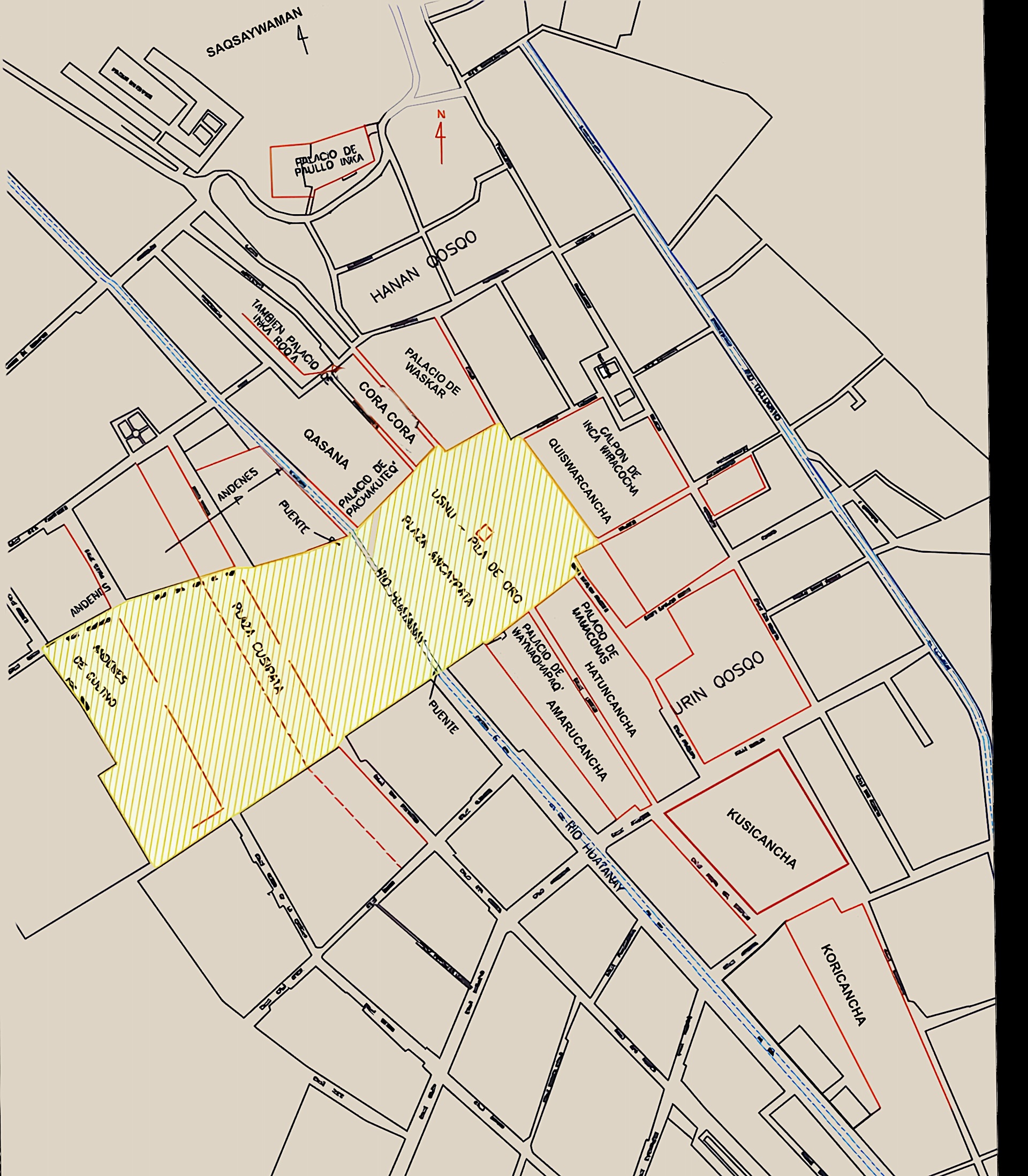
The alignment, measured
From the highest point of Saqsaywaman, the circular tower of Muyuqmarka, to the Koricancha there are 1,460 metres in a straight line, oriented 32° west of geographic north. We have placed the eleven sites on the map of Cusco, using the open map OpenStreetMap and our own aerial photograph, and measured how far each one lies from that line.
Swipe sideways to see the whole map
| # | Site | Distance to the line |
|---|---|---|
| 1 | Saqsaywaman (Muyuqmarka) | start of the line |
| 2 | Colcampata (San Cristóbal) | 14 m |
| 3 | Palace of Huáscar * | ≈ 4 m |
| 4 | Cora Cora * | ≈ 40 m |
| 5 | Qasana * | ≈ 77 m |
| 6 | Quishuarcancha (Cathedral) | 22 m |
| 7 | Hatuncancha – Acllahuasi (Santa Catalina) | 23 m |
| 8 | Amarucancha (Compañía de Jesús) | 64 m |
| 9 | Puca Marca * | ≈ 0 m |
| 10 | Kusicancha | 48 m |
| 11 | Koricancha (Santo Domingo) | end of the line |
Distance measured from the centre of each building; these buildings are 30 to 80 metres across. * Approximate position, taken from our aerial photograph (±40 m).
All nine intermediate sites lie within 80 metres of the line, and seven of them within 50 metres: the line crosses or grazes the great palaces and temples of Inca Cusco. It traces the backbone of the Inca city, from its highest sanctuary to the Temple of the Sun.
22.5°: the Chekkaluwa
The Koricancha has its own orientation. With ground-penetrating radar, our team measured that the royal door of the Koricancha, on Calle Arrayanniyoq, the street that separates it from the Kusicancha, and the royal road that climbed from it towards Saqsaywaman are oriented 22.5° west of geographic north. The open map confirms this independently: the walls of the Church of Santo Domingo, built on the Inca foundations of the Koricancha, run at 22.1°.
22.5° is not an arbitrary figure. It is the angle of the Chekkaluwa, the “Great Diagonal” of the Andean chakana: half of the 45° of the Qhapaq Ñan, described by Carlos Milla Villena (1979) and María Scholten (1977), who translated it as “the path of truth”. Andean geometry predicted 22.5°; the Koricancha measures it.
The road and the line are not the same: they differ by about 10°. The road leaves the Koricancha at 22.5°, and the streets that climb from it turn gradually (Romeritos and San Agustín, 28°; Loreto, 31–33°) towards the summit of Saqsaywaman, at 32°.
Sources: street map © OpenStreetMap contributors (ODbL); measurements and calculations by Pi Rambla Heritage Foundation (2026). C. Milla Villena, Génesis de la cultura andina (Lima, 1979), p. 160. M. Scholten (1977), p. 16, cited in A. Pi Rambla, Umbilicus Mundi (EY Peru, 2024).